Mike Kaldy
Mike Kaldy
12 July 2024
Planning
I really did very little planning for this ride - however, I’ve ridden the OTET section from Columbus to Massillon maybe a half dozen times while riding the ~200 miles from where I live in Columbus to where they live in Brookfield. I put a little bit of time into researching the route sections I didn’t know to see how available I thought resources would be, particularly in the middle of the night. For me, that meant Xenia Station was a point of interest - I ended up stopping and dropping off a bottle of gatorade and bag of potato chips on my drive to the start, although I wouldn’t have spent the time doing it if I’d known that there was a water fountain right there.
As far as logistics are concerned, I knew I wanted to get a hotel in Cincinnati so I could get some rest and go right out to the start at midnight or so. It turned out the hotel was significantly cheaper in Covington, KY, so I opted for the extra mile or so to save $50. I ended up reaching out to one of my bike friends the day before (when I decided I was going to do this ride) to see if I could leave my vehicle at his place for a while since I didn’t know when I’d be able to get back to get it. Ideally I’d be returning to pick it up by bike, so weather would play a role.
There are also buses available from Columbus to Cincinnati, but I had trouble figuring out how/if I could reasonably take my bike so I opted against that this time.
Preparation/Training
I didn’t do anything in particular preparing for this than I do for any other big ride/race - that being said, I do 7 or 8 100+ mile (7-18 hr duration) races per year, in addition to another dozen or so training rides of the same length, so this could vary significantly for others. I did my normal carb-loading for the 2 days before, which I take pretty casually on the first day and then ramp up to 10-14g/kg the day before. This has worked well for my other events, and I usually accompany this with decreasing training volume that week and less than 1h each day in the 2 days leading up to an event.
As far as navigation was concerned, I picked a ridewithgps file (https://connect.garmin.com/modern/course/256055095) that was posted on the OTET page and loaded it on my Garmin Edge 1030+. I know I get 20h+ of runtime in regular mode with my power meter and HRM, so I was pretty confident I wouldn’t run out - for reference, I ended at ~19.5h with about 10% left which is approximately 2h remaining.
Navigation
As mentioned above, I picked a ridewithgps file that was posted on the OTET page and loaded it on my Garmin Edge 1030+. I always load the route the night before prior to starting, because sometimes it takes along time or can fail. I had no issues with this particular file, but it still took 10+ minutes to load completely. I then power off my GPS and it’s ready to go when I turn it back on.
Near the start, navigation was a little confusing for me - the OTET signage differs slightly from the GPS directions, but it seems like this is intentional to keep you off of more roads - perhaps as more sections of trail have opened? After leaving Cincinnati, I thought the directions were very clear and easy to follow via the GPS or OTET signage all the way until maybe the last 5 miles. I’m guessing most people will have very slight variations along the route in cases like this, plus different stops for food/drinks.
Nutrition
I always start my day, race or not, with a big bowl of oatmeal with chocolate, protein powder, and a banana. I also had a coffee I got the night before from McDonald’s, so that was ready to go.
I had planned to follow a similar nutrition plan to what I do during races or other long training rides - I commonly drink sugar water (plain sugar at about 70-80g/bottle) with electrolytes (LMNT) at a rate of close to 1/hr. However, I knew this ride was also going to be different in terms of intensity compared to a race - so the breakdown of what I’d eat would likely need to be different since I was planning on staying in zone 1/2 for the majority of the ride. My initial plan was to eat snacks stuffed in my jersey pockets ( really whatever you want that you know works for you - it takes some trial and error), plus my sugar water and gatorade for the first ~140 miles to Westerville. With my stop in Xenia Station to refill, that worked out just fine. Beyond that, the plan was stopping for fast food in both Westerville and Millersburg, and then as needed from there on out.
In short:
Fruit Strips
Fig Newtons
Potato Chips
Banana
Sugar/LMNT
Clif Bloks
Stroopwafels
Belvita Crackers
Equipment
I recently sold my road bike for one “do-it-all” bike - a Specialized Crux (Rival AXS 1x 44t chainring with 10-44 cassette) with 2 wheelsets. I have one deep aero Reserve 52/63 wheelset for road and Ethirteen XCX Race wheelset for gravel. I’ve done 200+ mile stretches on both wheelsets, but opted for the deeper road wheels with GP5000 30mm tubeless tires for this ride, even though there was perhaps a slightly higher risk of flats. They are a bit less effort, and no matter hwo you cut it this is a big ride that I’d like to finish in the daylight. The other wheels with something like S-works Pathfinder 42mm tires are perhaps 1mph slower, but also more comfortable and puncture resistant. If on a road bike, I’d recommend 32mm wide tires like the GP5000S TR.
I carried the following items in an Ortlieb saddle bag:
- Spare tube
- Patches
- Tire lever
- Multi-tool
- Tire boot/patch
- Credit card, insurance card, ID, cash
- 2 CO2s + Inflator
- Chain master link
For lighting I used a Cycletorch 500 and had a Nightrider 300 as a backup, and my taillight was a cheap one from Amazon. I can’t say enough good about these lights though - I used them throughout the Polar Roll Ultra last winter and they have at least 24h of runtime.
It’s really pretty light, but I was pretty confident in my setup and have a lot of miles on it.
Ride Day
I had planned to start riding around midnight, but I ended up getting to my hotel a little later than expected and had some trouble checking in so I pushed that back to 12:30-1:00am because I wanted at least 4h of sleep. You really want more than this, because it gets to you as much as the fatigue later in the day.
I was woken up by pouring rain a little after midnight, even though the forecast had something like a 5% chance of rain. That lasted until after 1:00am, and at that point I just figured I’d have to get wet no matter what because the ground was already wet. I finished up breakfast and hopped on the bike with all my stuff backed in my jersey (food, extra sugar, phone/credit card). I wore exactly what I was going to ride in to the hotel because I was only going to be able to leave with whatever I was taking all the way to Cleveland.
I set off just after 1:20am. It was surprisingly warm considering the low was supposed to be in the 60s for the night. I was pretty bummed it had rained for the start, as it makes visibility worse, keeping glasses clean difficult, and quite foggy…aside from just having a soaked chamois.
The first 4h were pretty uneventful, although I did have to be pretty diligent about looking for treefall - there were a couple that could’ve got me if I wasn’t so attentive. The fog started lifting around Xenia, and shortly after that it was daybreak. I think I noticed it being fully light around London, right when my Cycletorch 500 light started showing low battery.
From there, I knew most of the trail out to Massillon, so nothing terrible memorable happened in that stretch.
My first major stop was at Wendy’s in Westerville, around mile 140, which is right on the route. I had 2 sausage biscuits, french toast sticks, potato wedges, and a coffee. Stopped time was about 22 min.
From there, I knew I had a lot of water options spaced out in Mt Vernon, Gambier, Danville, and Millersburg. I spent another few minutes at each fountain topping up my bottles and spraying myself with quite a bit for cooling. FOr reference, I carried two 22oz bottles in caged on the bike and one 16oz soft flash in my jersey pocket. 1 was always plain water, 1 was always sugar water/electrolyte, and the last was either water or gatorade. I seem to get a lower tolerance for sweet stuff after 10h+, so that varied a little later in the ride.
The next major food stop was in Millersburg (~mile 220), where I also went to Wendy’s. THis time it was lunch, so I got my usual $5 biggie bag + a frosty. This meal was a junior bacon cheeseburger, spicy nuggets, fries, frosty, and coke. I was pretty stuffed again, but I know it gets harder to eat later in big rides for me so I did what I could.
The next stretch after this is perhaps my favorite - rolling hills on country roads after finishing the last few miles of bike path. There’s also a place called “Biker’s Rest” near Dalton, which is just a house that usually has ice water out (felt so good) and also offers tent camping in their yard. The last 5 miles of this road stretch was just chip-sealed the same day with coarse gravel, so it was a bit more of a chore than I expected - and also a much higher flat risk, which I was happy to not have occur. From there to Massilon is a mix of gravel and paved towpath, generally trending downhill.
From Massillon north was all new to me - so I was pretty excited to be a little more mentally engaged with new views. It’s mostly crushed limestone towpath, which is great when dry but terrible and destructive when wet. Luckily for me, it was totally dry and perhaps better than paved. Up to around Akron, it is generally a very slight climb with quite a few road crossings - then generally downhill all the way to Cleveland after some big rollers. It was this area I struggled the most with finding water - some fountains were off and there just weren’t many in general. I finally made it to Canal Fulton, where I stopped for about 12 min to get a coke and water and pull out my contacts. My eyes were pretty beat up after the first 4h of having to look over my glasses, but they were good for the rest of the day after that - so I’d recommend carrying a contact case/solution if you wear them. It was at this point I gave my wife my ETA in Cleveland at Edgewater Park - we were planning on visiting family in the area that weekend, so it worked out perfectly for the required trip logistics. At this point I estimated I was about 4h out - that was pretty close, maybe an extra 20 min or so.
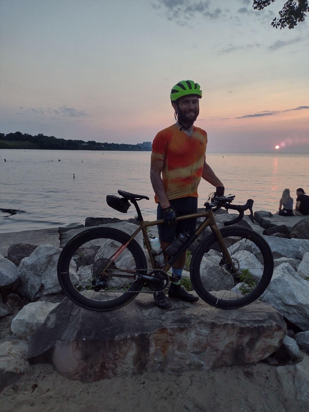
As much as I love riding and spending a whole day on the bike, seeing Cleveland was a pretty joyful moment - once you can see the city you’ve made it - although there are a couple kickers/bridges to make it over. Then you can enjoy the Edgewater Park atmosphere for sunset if you planned/timed it right. I’d plan on having food pretty much immediately if you can manage, because everyone there is grilling and it smelled so good.
I had ~19h 40m elapsed time from Covington, KY to Edgewater Park (average speed ~16.8 mph, moving avg ~18.1 mph). My initial plan was ~18h, so really not too bad of an estimate. The only things that slowed me down a little were the rain/fog at the start, combined with unfavorable/abnormal winds. It was mostly calm the rest of the day after hitting Millersburg, until I was within 5 miles or so of Lake Erie, when it became a headwind again. I’d say favorable winds could probably save 1h+, or unfavorable winds could cost you even more…but that’s biking.